Helsingør, Denmark, September 24, 2019,
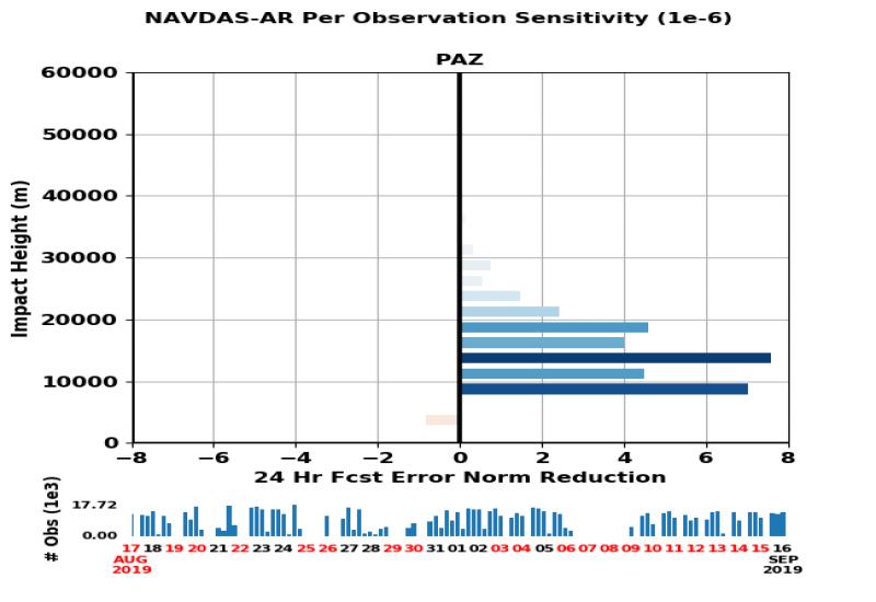
Researchers of the U.S. Naval Research Laboratory (NRL) announced that data acquired by the Radio Occultation and Heavy Precipitation experiment aboard PAZ (ROHP-PAZ) are being assimilated operationally into the US Navy Global Environmental Model (NAVGEM) which is run operationally by Fleet Numerical Meteorology and Oceanography Center (FNMOC) since 15Aug2019. Real time monitoring of the innovations are available to the public at: https://www.nrlmry.navy.mil/metoc/ar_monitor/. The announcement was made at the 7th International Radio Occultation Working Group (IROWG-7) meeting and EUMETSAT ROM-SAF User Workshop held in Helsingør, Denmark. NRL provided the capability to assimilate PAZ ROHP-PAZ to FNMOC, and continues to contribute to the development and maintenance of the NAVGEM system for weather forecasts and related services. The present quality levels of the PAZ data have shown consistent positive impact to weather analysis and forecasts similar to the other radio occultation missions. This effort is extremely useful to the RO community, and a significant step towards the assimilation of PAZ data into other operational weather prediction models.
The ROHP-PAZ experiment is led by the Earth Observation group at the Institute of Space Sciences (ICE-CSIC) and Institute of Space Studies of Catalonia (IEEC). Signals transmitted by the Global Positioning System (GPS) are acquired at the PAZ satellite when these transmitters are setting behind the limb of the Earth (‘occulting’). These signals contain information about the vertical structure of thermodynamic variables of the atmosphere, improving the weather forecast when injected into the prediction models. PAZ radio occultation data are downloaded to the ground and processed to intermediate products in near-real time by the USA National Oceanic and Atmospheric Administration (NOAA) and the University Corporation of Atmospheric Research (UCAR), through agreements with the ICE-CSIC/IEEC. These products, suitable for assimilation into the numerical weather prediction models, are currently being disseminated in near real time to NOAA related centers, while waiting for prompt dissemination to weather services worldwide through the Global Telecommunication System of the World Meteorological Organization (WMO).
ROHP-PAZ is an opportunistic experiment aboard PAZ low Earth orbiter, a satellite owned, operated and exploited by HISDESAT. The experiment is funded by the Spanish Ministry of Science, Innovation and Universities.
