
ROHP-PAZ
THIS CAMPAIGN HAS BEEN SUCCESSFULLY COMPLETED, SEE DETAILS AND FINAL OUTCOME IN [Padullés et al., 2016].
A ground experimental campaign is being conducted before the launch of the PAZ satellite, with the goal of starting the process of identifying and understanding all the factors that might affect the polarimetric RO observables. It is a collaboration between the ICE-CSIC/IEEC and the department of Signal Theory and Communications at the Polytechnic University of Catalonia (UPC).
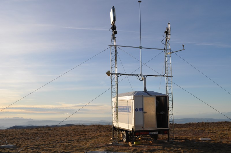
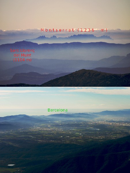
The selected site is a ~1700 m mountain peak (Puig Sesolles) in the Natural Park of Montseny, ~50 km N-NE of Barcelona. The site is a military terrain, enclosed and protected, and with available power supply. It has clear views over the horizon in the South (East to West) direction, an area in which intense precipitation events tend to occur a few times per year. The equipment will be deployed and operating for a long time, minimum of 6 months.
The campaign uses ICE-CSIC/IEEC's GOLD-RTR receiver [Nogués-Correig et al. (2007), Cardellach et al. (2011)], an open-loop receiver initially designed for collecting GNSS signals reflected off the sea surface. The receiver has been adjusted to track occulting GNSS radio-links.
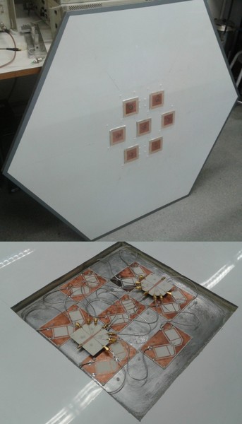
A double polarization (H and V) GNSS antenna has been designed and manufactured by the UPC team for this particular ground-based experiment. The antenna is a phase-array made of 7 elements, each of them being a square patch built using a Rogers 4003 substrate, and symmetrically fed by four probes. It provides a pattern of 12.9 dB peak gain, 45 degrees half-power beam-width, and <-35 dB cross-polar isolation at the peak (better than -30 dB in the main lobe).
The antenna has been mounted on an articulated arm, rotated by an azimuth/elevation positionner and its controller towards the desired GNSS satellite source. The selection of the GNSS satellites to be tracked is made based on a-priori information of the GNSS constellation, the azimuth and elevation mask of the site, and the presence of rain.
When no rain is present, the acquisition schedule follows a daily pattern, tracking always the same satellites at the same orientations. Except for blind spots we seek to avoid (obstacles), the system points to GNSS satellites laying between 90 and 270 degrees azimuth and 30 to 0 degrees elevation. The extensive set of free-of-rain data will be valuable to understand the polarization issues that do not relate to precipitation (multipath, ionosphere, transmitters' patterns, other instrumental issues).
From the ICE-CSIC/IEEC's premises, the local weather radars are checked automatically every 6 minutes (updating frequency of the nearby radars). The locations of the GNSS satellites in view (within the azimuth/elevation mask) are compared to the reflectivity values measured by the weather radar, and the experiment is modified when a coincidence is detected. Then, the system starts tracking the particular GNSS satellite located along the direction of the rainfall, instead of the satellite scheduled by default.
In this way, the campaign will provide both a self-consistent set of polarimetric data free of rain, together with those GNSS occulting across precipitation events.
The data are stored locally, and also available through an Internet link. This link is also used to update default and/or rain acquisition schedules.
In addition, a UPC's L-band radiometer has also been deployed in this campaign, pointing towards the same direction than the GNSS polarimetric antenna so as to provide collocated atmospheric opacity in the same direction of the GNSS antenna.
UPC has also been responsible for the experiment logistics, including the trailer used as a shelter for the equipment, UPS,... , the towers, and the manpower to condition the experimental site. Special acknowledgments to the Spanish Air Force and the General Direction for Infrastructure of the Spanish Ministry of Defense, for availability of the site and its facilities.