
ROHP-PAZ
ROHP-PAZ is a GNSS RO polarimetric experiment aiming to provide high-resolution atmospheric profiles of thermodynamic variables and co-located information on intense precipitation.
If successful, the polarimetric RO will represent the first technique able to provide these complementary information on precipitation. This is a relevant input for studies on heavy and violent rainfall events, which being poorly represented by the current-generation of Numerical Weather Prediction and General Circulation Models (WPM and GCM respectively) appear to be difficult to forecast on all time-scales. Given that climate change is likely to influence the intensity and the frequency of occurrence of extreme precipitation, it is of a primary importance to develop tools able to progress our understating of the structure of these intense events [Wentz et al., 2007, Allan and Soden, 2008].
The ROHP-PAZ experiment will take Radio Occultation measurements at two linear polarizations, H and V.
The data obtained separately by the H and V ports of the RO antenna and processed in separate channels by the IGOR+ receiver will be used in two ways:
It is the first time ever that polarimetric observations will be acquired from a RO mission. The GNSS signals, transmitted at L-band and Right-Hand Circular Polarization (RHCP), are in general little affected by the cloud coverage and rain, being called "all-weather" signals for their ability to propagate through any conditions of the Earth's atmosphere.
Being GNSS signals so insensitive to rain and clouds, how do we envisage to extract rain information from them?
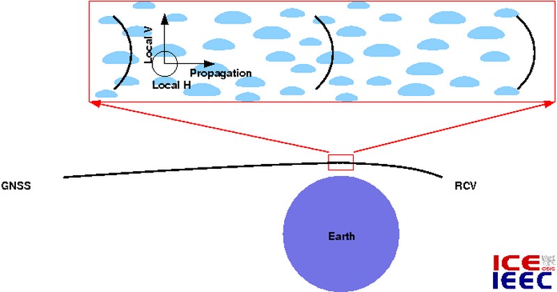
On one hand, the occultation radio-link crosses the troposphere tangentially around its lowest point (called tangent point). Tangentially means very close to the horizontal direction in a local coordinate system. On the other hand, the rain droplets tend to become oblate and flattened by the dragging effect of the atmosphere while falling, especially when their diameter is similar to or larger than ~2 mm, typical of heavy and violent rain. The highest the rain rate the highest the droplet size, and thus its flattening ratio. Therefore, the spherical symmetry is broken, and the locally vertical and horizontal dimensions of the rain drop are not the same, which might affect differently the vertical and horizontal components of the signal polarization traveling along the local horizontal plane.
The effect is expected to be small, being the GNSS signals in the L-band of the electromagnetic spectrum, with ~20 cm electromagnetic wavelength. This is two orders of magnitude higher than the droplet size (Rayleigh regime). In spite of this, it is not the first time than L-band signals have detected depolarization induced by heavy rain: Peters et al. (2008) found depolarization of GOES telemetry down-links (RHCP 1.5 GHz) provoked by presence of heavy rain along the radio-link. Moreover, the S-band polarimetric radars (3 GHz), of ~10 cm electromagnetic wavelength (same order of magnitude as L-band GNSS') do use the polarimetric properties to quantify the rain and rain rate in back-scattering observations. Because the GNSS system provides a very precise measurement of the carrier phase, it is likely that the rain signature will be found in polarimetric phase features. In fact, the specific differential phase used in polarimetric S-band radars is a very good estimator of rain rate and is not affected by attenuation.
A large number of factors are not well characterized at the moment: such as the noise level of these effects; the discrimination between rain rate and total length of the path traveled inside the precipitation volume; the effects of the canting angle of the droplets (the flattening plane might not be horizontal); ionospheric and instrumental factors; multi-path within the receiving satellite platform; ...
ROHP-PAZ is then a proof-of-concept experiment to check the potential use of the polarimetric features to detect and quantify precipitation events along the occultation radio-link.