ROHP-PAZ

notícies

09-10-19

PAZ radio occultation data disseminated worldwide continuously in near real time

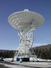
PAZ data are downlinked to NOAA's Fairbanks ground station, using its 26-meter diameter antenna (pictured). NOAA's Partner Antenna Access Network (PAAN) program utilizes NOAA's new enterprise network architecture to provide high-speed, high-capacity, reliable and redundant network connectivity to remote sites such as the Fairbanks Command and Data Acquisition Station (FCDAS). Due to its high-latitude location in Alaska, FCDAS is able to offer frequent opportunities for downlinks from partner satellites in high-inclination polar orbits, giving weather satellites of cooperating agencies the ability to provide critical weather data to the National Weather Service and global meteorological agencies in near real time. Credits: NOAA/FCDAS.

On Friday October 4, 2019,

The USA National Oceanic and Atmospheric Administration (NOAA) started dissemination of the PAZ radio occultation data and products in near real time (NRT) and continuously. Thanks to the agreements between NOAA, ICE-CSIC/IEEC and Hisdesat, the USA agency can downlink ROHP-PAZ data to NOAA gound stations once per orbit, quickly process them at UCAR premises, and broadcast them through the Global Telecommunications System (GTS) of the United Nations' World Meteorological Organization (WMO). This system is used to share data by worldwide weather services. These data, at very short latency (less than three hours since the measurement is conducted abord PAZ), can then be ingested in the numerical weather prediction models, to improve the weather forecast.